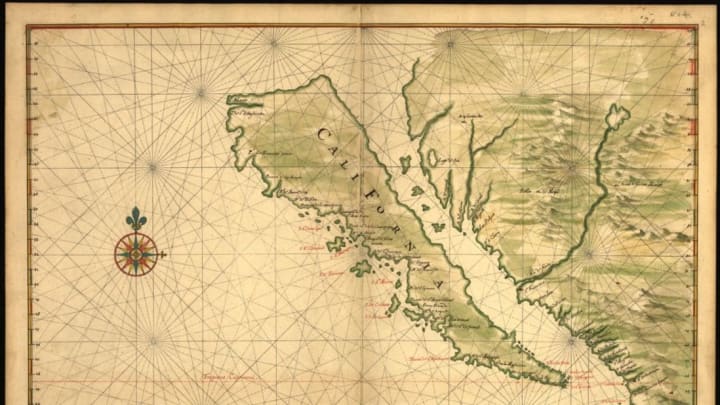
A 1639 Map Shows California as an Island

In the early days of mapmaking, plotting out the world was no easy task. It's not surprising that cartographers got some things wrong (it's probably more surprising how much they got right). One of the most widespread misconceptions in the 16th century involved an area of the mostly unexplored continent of North America, a place called California, which mapmakers often portrayed as an island.
The trouble began not with explorers, but with a writer. In his 1510 book Las sergas de Esplandián, Garci Rodríguez de Montalvo wrote "Know, that on the right hand of the Indies there is an island called California very close to the side of the Terrestrial Paradise; and it is peopled by black women, without any man among them, for they live in the manner of Amazons."
The island of California was strictly a figment of de Montalvo's imagination. Still, though the western coast of North America had typically been shown as a peninsula in the 1500s, when Spanish explorers visited the area in the 1600s, they concluded that the area was, in fact, an island.
At that time, maps were very valuable guides to new territory and, therefore, closely guarded. So how did this myth perpetuate? "The story is, the Dutch raided a Spanish ship and found a secret Spanish map and brought it back to Amsterdam and circulated it from there,” map collector Glen McLaughlin told Wired. (You can see McLaughlin's entire collection of Island of California maps, which he donated to Stanford, online here.)
And that may have been exactly what the Spanish wanted. "I've been told that Spain knew it wasn't an island, but it was politically expedient for others to think it was," writer and map enthusiast Rebecca Solnit said in a Stanford press release. "They weren't going to share what they knew with everybody else."
By 1622, drawing California as an island was all the rage among European mapmakers. The map above, part of the collection of the Library of Congress, was drawn by Dutch cartographer Johannes Vingboons in 1639. The misconception persisted even after Eusebio Kino, a Jesuit priest, led an expedition in the area between 1698 and 1701 and published a report—complete with map called "A Passage by Land to California"—that debunked the notion. It would take another half-century before California became reattached to the continent in maps. In 1747, even King Ferdinand VI of Spain weighed in—his royal decree declared "California is not an island."
The Afternoon Map is a semi-regular feature in which we post maps and infographics. In the afternoon. Semi-regularly.