What Is El Niño, and Why Does It Have Such a Big Impact?
The periodic warming in the Pacific Ocean can bring flooding, blizzards, and heat waves to the U.S.

El Niño has taken on an almost legendary quality in the United States, entering the collective mind of the public in the late 1990s as an epic weather pattern that drenches California in an unending deluge of tropical moisture.
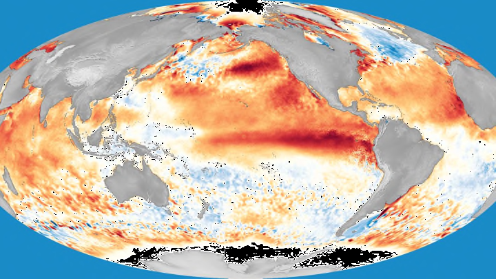
An El Niño is the abnormal warming of sea surface temperatures in the eastern equatorial Pacific Ocean. The event occurs when winds over the Pacific Ocean near the equator slow down or reverse direction, allowing unusually warm water to accumulate around the eastern part of the equatorial Pacific. When sea surface temperatures in this portion of the Pacific climb 0.5°C above average for seven consecutive months, it’s officially considered an El Niño. An upward shift of one-half of one degree doesn’t sound like much—but, in a similar way to a fever in the human body, it doesn’t take a lot of abnormal heat to make a huge impact both on the ocean and the atmosphere above it.
How can warm water in the Pacific Ocean affect the weather thousands of miles away? Everything is connected. One of the most heavily advertised effects of El Niño is that it can squash the Atlantic hurricane season as the warm water triggers thunderstorms in the eastern Pacific, causing strong upper-level winds to flow east over the Caribbean and Atlantic. This wind shear tears the tops off thunderstorms, keeping tropical activity to a minimum. However, the warmer water can also alter the jet stream, which is how we most commonly feel its influence here in the United States.
A River of Wind
The jet stream is a fast-moving river of air in the upper levels of the atmosphere that’s usually located between 25,000 and 35,000 feet, the typical cruising altitude for commercial jets. This ribbon of powerful winds is caused by the temperature difference between the tropics and the poles. Weather exists as a result of nature trying to balance itself out—in this case in the Northern Hemisphere, rising warm air in the tropics flows north toward the Arctic, turning east thanks to the Coriolis effect. The resulting river of westerly winds is the jet stream.
During the summer months, the jet stream is usually weaker and stuck in the higher latitudes. This is why weather is generally calmer during the summer, allowing long stretches of hot, humid weather only broken by occasional pop-up thunderstorms. During the cooler months, however, the north-south temperature gradient is much sharper, allowing the jet stream to dive south over the United States (and sometimes even farther south than that). This curvy, dippy jet stream provides us a constant offering of volatile weather, bringing everything from heavy rain or snow to extreme bouts of cold weather.
Weather Woes
This is where El Niño factors in. There are actually two jet streams in the Northern Hemisphere: the polar jet stream, which circulates in the higher latitudes, and the subtropical jet stream, which we’ll often find around the southern United States. The polar jet is what brings us our deep shots of frigid air during the dead of winter, and the subtropical jet is often at least partially responsible for the huge, historic snowstorms that occasionally whomp the East Coast.
When the water in the eastern equatorial Pacific Ocean is abnormally warm like it is during an El Niño, it can affect air temperature above the surface. The warmer air allows the subtropical jet stream to grow stronger and establish itself over the southern United States, shoving the polar jet stream farther north near the U.S.-Canada border. This brings stormy weather to the southern half of the United States, often manifesting itself in wet low-pressure systems that smack California before slowly trundling across the rest of the country. This also tends to keep the northern United States drier and warmer than normal, though snowy conditions and arctic blasts aren’t uncommon.
If you hear people talk about El Niño causing flooding and snow out west or news anchors report that “El Niño brought heavy rain to Los Angeles yet again today,” take comfort in the fact that you now know that’s not true. El Niño doesn’t directly cause rain or snow or heat or cold in the United States, and El Niño doesn’t make landfall like a hurricane, either, since it’s just abnormally warm ocean water. El Niño won’t always be the cause of our weather woes, but it sure doesn’t help.
A version of this story ran in 2015; it has been updated for 2023.