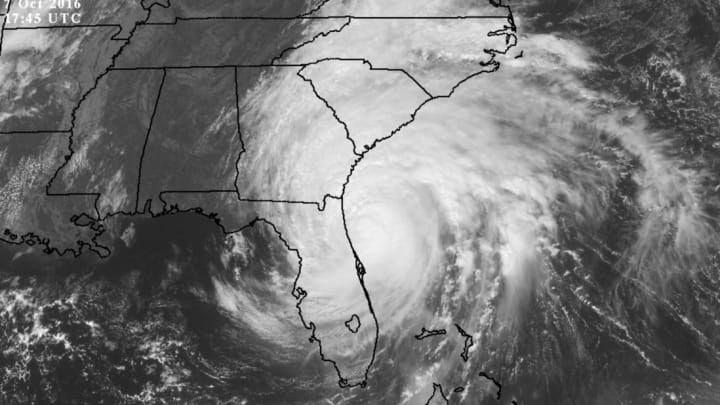
Matthew Hits Florida, Continues Up the East Coast

The eye of powerful Hurricane Matthew is just a few dozen miles off the eastern coast of Florida this afternoon, Friday, October 7. The storm’s strong winds and flooding have caused damage up and down the Florida coast over the past 24 hours, and the storm is far from over. The absolute worst-case scenario didn’t play out, thankfully, but there’s still the chance for potentially deadly impacts from this storm as it continues to affect Florida, Georgia, and the Carolinas.
As of 2 p.m. EDT, the National Hurricane Center found that Hurricane Matthew was still a major hurricane—though downgraded from category 4 to category 3—with sustained winds of 115 mph in the storm’s eyewall. The hurricane is steadily moving north-northwest, a forward motion that’s brought it parallel to the Florida coast but kept the eyewall just a dozen or so miles east of land. As the storm continues moving generally northward and encounters a southeastern coast that curves northeast, forecasters expect the strongest part of the storm to draw closer to shore. The coasts of Georgia, South Carolina, and North Carolina are particularly vulnerable over the next 36 hours.
The National Hurricane Center’s forecast for Hurricane Matthew at 2:00 PM EDT on October 7, 2016. Image credit: Dennis Mersereau
Powerful winds are likely along the southeast coast as the center approaches the area on Friday night and through the day on Saturday. Hurricane force winds (74 mph or greater) are possible from Jacksonville, Florida, up to Wilmington, North Carolina. Tropical storm force winds are possible across inland counties and as far north as the border between North Carolina and Virginia. Even small flying debris could seriously injure you, so please stay inside during the peak of the storm if you live in this area.
This region of the country is extremely vulnerable to a storm surge, the sea water pushed inland by strong winds. Current forecasts call for a potential storm surge of 6 to 9 feet as far north as Edisto Beach, South Carolina, an area that includes St. Augustine and Jacksonville in Florida, Brunswick and Savannah in Georgia, and Hilton Head Island in South Carolina. Storm surge flooding has already caused damage throughout eastern Florida, with several harrowing videos surfacing on social media showing floodwaters approaching occupied buildings.
The Weather Prediction Center’s rainfall forecast for the week between October 7 and October 14, 2016. Image credit: NOAA/WPC
Not only will the wind and sea cause damage, but flooding from heavy rain is particularly concerning with this storm. Matthew could produce more than a foot of rain along coastal areas of Georgia, South Carolina, and North Carolina, with half a foot of rain or more possible along the eastern halves of these three states. This much heavy rain in such a short period of time will likely lead to widespread flash flooding, especially since parts of eastern North Carolina are already swamped from recent rains. The excess water will quickly overwhelm local waterways, and roads in flood-prone areas will submerge with relative ease. Make sure you know alternate ways to get where you need to go this weekend if you can’t just stay home altogether.
Meteorologists used some of the strongest language possible in the statements they issued ahead of Hurricane Matthew. We knew that the eye of the storm would come very close to shore in Florida, and all evidence suggested that the eye would come close enough that its powerful eyewall would drag along the shoreline. The eye stayed just far enough to the east that most of the coast missed the worst winds, but the difference was just one or two dozen miles in most spots.
Forecasters will undoubtedly receive strong criticism for sounding “alarmist” in the lead-up to this hurricane, but the enhanced warnings were absolutely warranted. Had the hurricane wobbled just a dozen miles to the west, the situation in Florida would be much bleaker than it is now. Think of it this way: When the forest is on fire, you don’t stop to yell at the firefighters because your neighborhood didn’t burn down like they said it would. If there has ever been a storm to go all-out on warning people of the potential hazards using the strongest terms possible, it was Hurricane Matthew.