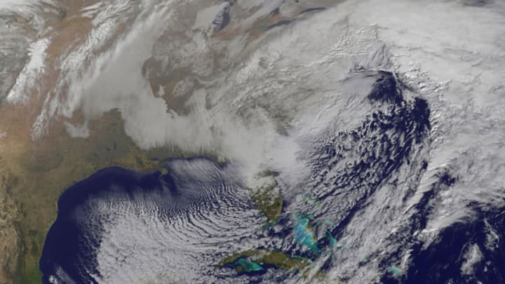
See These Amazing Photos of Winter Storm Jonas From Space

If you live on the East Coast or in the mid-Atlantic region, the view out your window right now is probably a blur of blustery snow. Winter storm Jonas has been pummeling everywhere from Virginia to New England with snow mounting several feet high in places. The blizzard is plenty photogenic on the ground—but from up in space, it's something else entirely.
Scott Kelly, who's spending a year on the International Space Station, has tweeted several photos of the storm blanketing the coast:
Massive #snowstorm blanketing #EastCoast clearly visible from @Space_Station! Stay safe! #blizzard2016 #YearInSpace pic.twitter.com/oq6ewYaTPQ
— Scott Kelly (@StationCDRKelly) January 23, 2016
As #blizzard2016 passes over #Chicago, the #EastCoast seen in distance clearly has a long way to go. #YearInSpace pic.twitter.com/qMrkTXo9ie
— Scott Kelly (@StationCDRKelly) January 23, 2016
NASA released a model of the storm created by their Center for Climate Simulation supercomputer:
Our supercomputers @NASA_NCCS crunched the data to show the cloud flow of #Blizzard2016: https://t.co/W7NwdBQbbnhttps://t.co/qHL3pp7Vgk
— NASA (@NASA) January 22, 2016
And a series of satellite photos of the storm in action:
NASA's Visible Infrared Imaging Radiometer Suite (VIIRS), which relies on light reflecting from the moon above and the infrastructure below, captured this image, at 2:35 a.m. EST on Friday, showing the storm sweeping across the country:
We’re watching #Blizzard2016 from space. Here's a new satellite view from 2:35am ET today: https://t.co/6YTbRO5KiS pic.twitter.com/R8n3OemO3r
— NASA (@NASA) January 22, 2016
And at 2:15 a.m. EST on Saturday, it took this image of the storm right above major cities along the East coast:
A Blizzard by Moonlight https://t.co/1fyhNjYl1p #NASA pic.twitter.com/6V6lXWp4qm
— NASA Earth (@NASAEarth) January 23, 2016