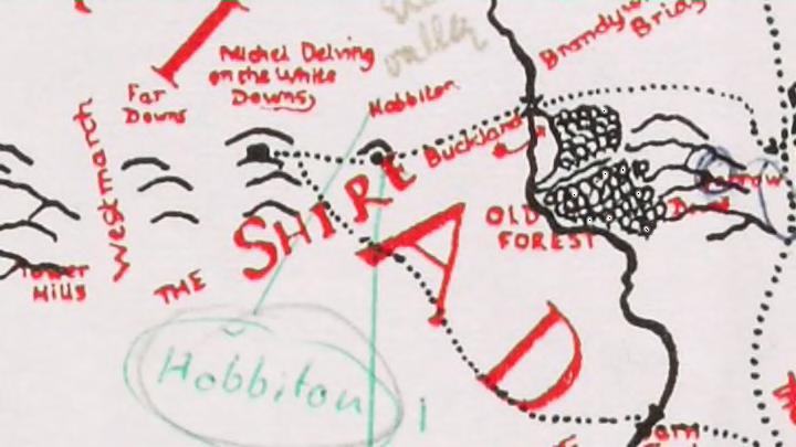
Recently Discovered Middle-Earth Map Has Annotations By J.R.R. Tolkien
By Anna Green

In the 1960s, author J.R.R. Tolkien commissioned artist Pauline Baynes to create a colorful illustrated map of Middle-earth, the setting of his famous fantasy novels, including The Hobbit. In order to ensure that Baynes got everything right, down to the last tiny ship and bit of Elvish spelling, Tolkien provided the artist with a massive annotated map full of his own notes and thoughts on Middle-earth’s geography. For decades, the annotated map sat collecting dust in Baynes’s home, but now, it has been acquired by Oxford’s Bodleian Libraries, where it will soon go on public display.
Though many of Tolkien’s annotations center on small geographical changes and spelling corrections to the original Middle-earth map drawn by his son, Christopher Tolkien, for the 1954 edition of The Lord of the Rings, others provide insight into the way Tolkien connected his richly detailed imaginary world to locations in the real world. For instance, one note mentions that “Hobbiton is assumed to be approx. at [the] latitude of Oxford,” while in another Tolkien writes, “Minas Tirith is about [the] latitude of Ravenna [northern Italy] (but is 900 miles east of Hobbiton more near Belgrade). Bottom of the map (1400 miles [from Hobbiton]) is about latitude of Jerusalem.”
While fans of the novels likely know that Middle-earth was loosely based on the geography of Europe, they might be surprised when they see the parallels between Tolkien’s fantasy realm and real places lined up so explicitly. Tolkien saw a connection between Oxford, where he lived and wrote for many years, and Hobbiton, the idyllic home of the hobbits and the starting point of his series.
The map also showcases Tolkien’s attention to detail, and the phenomenal scope of his imaginary world. Tolkien not only added more locations to Baynes’s edition of the map than appeared on the initial version, but added notes about everything from which animals should be included, to the colors of ship sails ('Elven-ships small, white or grey...Numenorean (Gondor) Ships Black and Silver...Corsairs had red sails with black star or eye’).
"The creation of maps was central to Tolkien's storytelling and this particular map provides a glimpse into the creative process that produced some of the first images of Middle-earth, with which so many of us are now familiar," said Chris Fletcher, Keeper of Special Collections at the Bodleian Libraries in a statement. "We're delighted to have been able to acquire this map and it's particularly appropriate that we are keeping it in Oxford. Tolkien spent almost the whole of his adult life in the city and was clearly thinking about its geographical significance as he composed elements of the map."
Check out Tolkien’s annotated map and Baynes’s final illustrated version below.
The Tolkien Estate Limited 2016
HarperCollins Publishers Ltd 1970