Humans love it when the temperature hovers around 70℉. We’re more productive at work, babies sleep better at night, and tourists worldwide think [PDF] it’s the ideal temperature for a visit (except for beach vacations). When the mercury rises above 70℉, our unhappiness shoots up too.
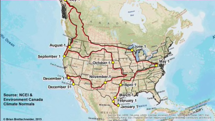
But you don’t have to stay in the climate-controlled indoors to maintain this optimum temperature. Climatologist Brian Brettschneider created a 13,235-mile road trip through North America that keeps you in 70℉ weather every day for a full year.
Using weather data from the National Center for Environmental Information and Environment Canada, Brettschneider plotted a route through places that have a daily high average of 70℉. (It will likely get cooler at night.)
The trip begins on January 1 in southernmost Texas. Get comfortable, because you’ll be in the Lone Star State for three months. On April 1, head east, arriving in Washington D.C. a month later. Now head northwest through Chicago, Wisconsin, and much of Canada; you’ll log a whopping 3873 miles in June on your way to Alaska. Return south as far as Portland, Oregon, then head back east through the Plains as far as Missouri. You’ll be there in late October. Spend the fall crossing west again. Celebrate New Year’s Eve in San Diego.
In all, you’ll pass through 31 states and three Canadian provinces.
If you want a shorter trip, Brettschneider also created a 9125-mile route that still begins in Texas and ends in California but omits Canada and Alaska.
And for those of you who like it hotter, he also plotted a 9949-mile trip that follows average daily high temperatures of 80℉. That map includes the 70℉ route in case you want to cool down.
It’s unlikely that you’ll see Brettschneider, who lives in Anchorage, Alaska, along the route—at least anywhere in the Lower 48. "I love the snow," he told CityLab.
