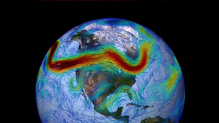
Trapped between two big high-pressure systems, Hurricane Harvey has stalled over Houston, to devastating effect. As the Washington Post notes, if the jet stream were to dip far enough south, it could push Harvey out. Unfortunately, that's not in the forecast.
But what is the jet stream?
A jet stream is a swift current of air that encircles the globe right around the cruising altitude of a commercial airplane. It's easy to forget that there are vast rivers of wind whooshing just a few miles above our heads at speeds that could put most hurricanes and tornadoes to shame, but jet streams affect us every day without our realizing it. These speedy winds drive or influence just about every weather system that we have the pleasure—or misfortune—of experiencing. Planes even use it to cut down on fuel consumption and travel times.
There are usually two jet streams in each hemisphere, the polar jet and the subtropical jet. When we talk about "the jet stream," we're generally talking about the stronger polar jet stream, because most of our weather is driven by it. It's typically found at the same latitude as the U.S.-Canadian border.
We're often guilty of oversimplifying weather events by blaming everything on a clash between warm air and cold air, but temperature gradients really do have an enormous impact on where the jet stream forms and how strong it is. Jet streams form as air in the upper atmosphere moves from south to north and gets deflected to the east by the Coriolis effect. The jet stream will get stronger if the warmer temperatures are to the south and the colder the air is to the north. This is why the jet stream strengthens and dips over the United States during the winter, while it weakens and retreats north into Canada during the heat of the summer.
The jet stream drives our weather through phenomena called troughing, ridging, and jet streaks. Troughs and ridges are curves in the jet stream that are analogous to low pressure (troughs) and high pressure (ridges). In the northern hemisphere, a trough is a southward dip in the jet stream and a ridge is a northward hump in the wind current. You can expect active weather ahead of a trough and quiet weather beneath a ridge.
A jet streak is an area of much faster winds within the jet stream itself. Winds in a jet stream routinely climb above 100 mph, but the wind in a jet streak can clock speeds of more than 200 mph in a boisterous weather pattern. Troughs and jet streaks often team up to create low-pressure systems at the surface, and that's what gives birth to most of our interesting weather. Winds don't flow in a straight line as they twist around a trough or speed in and out of jet streaks. Air collides going into a trough and diverges as it leaves a trough. The same goes for jet streaks.
The process of winds exiting a trough or a jet streak, known as divergence, creates a void in the upper atmosphere. Nature hates imbalance and will do just about anything to balance something that's out of whack. When winds diverge coming out of certain parts of the jet stream, air will rush up from lower altitudes to fill the void. This upward rush of air from the surface leaves lower air pressure at the surface, creating a low-pressure system that can trigger all sorts of nasty weather.
The jet stream is also one of those weather features that could feel the effects of climate change over the coming decades and centuries. Since these wind currents rely on sharp temperature gradients in order to form, a warmer atmosphere will lessen the temperature difference between north and south and possibly create weaker jet streams. A weaker jet stream could act more erratically, creating longer stretches of quiet weather—but also more frequent weather extremes.
