10 Propaganda Maps That Personify 20th Century Conflicts

A new exhibition showcases historic maps that summarized international conflict by depicting different world powers as people and animals.
War Map, an exhibit at London’s Map House, explores the satirical ways propagandists and mapmakers have sought to explain international conflicts in the 20th century, from making Hitler into a spider to showing Winston Churchill and Franklin Delano Roosevelt playing tug-of-war with Africa.
The maps (which we spotted from The Economist’s 1843 magazine) will be on display in London until November 18, and an accompanying coffee table book is available now. Check out a selection of the images below:
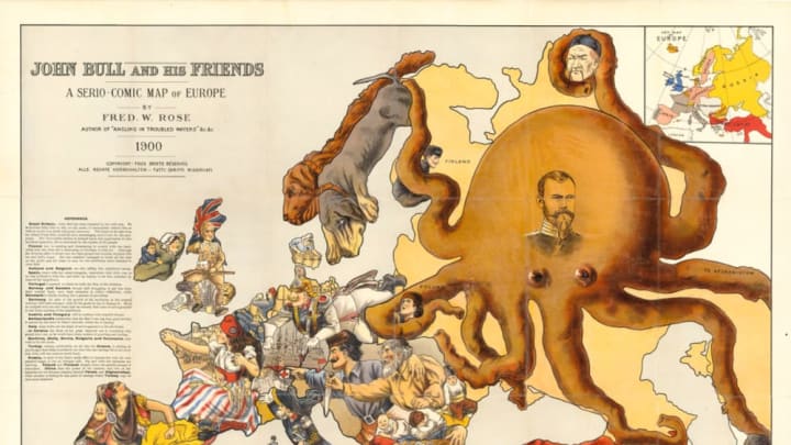
The style of influential mapmaker Fred Rose was widely copied by later satirical map designers.
Look closely at this highly detailed German depiction of Europe at the outset of World War I and you'll see Ireland trying to cut ties with England, Turkey jabbing at Crimea with a saber, and more.
This Moscow-made map includes a propaganda poem about Kaiser Wilhelm II in Russian at the bottom.
This German propaganda poster was made in Hamburg in 1915, and shows the Germans pushing their enemies away from both the Western Front and the Eastern Front.
In this World War II cartoon from Britain, the RAF drops propaganda leaflets on Berlin while Hitler and members of his top brass, Goebbels and Goering, shake their fists. Hiding under the table is Nazi Foreign Minister Joachim von Ribbentrop.
Churchill and FDR play tug-of-war with Africa in this cartoon. The U.S. began sending aid to North Africa in May 1942, while the UK had been fighting there with the other Allied powers since 1940. The European forces all had major colonial interests in the area, and a major objective for both sides was to gain control of the Suez Canal.
Many propaganda caricatures depicted the enemy as an octopus. This illustration shows Churchill as the aggressive octopus, and was probably made in German-occupied France.
This anti-Bolshevik cartoon was made in Bulgaria toward the end of World War II.
Austria-Hungary's tail is getting steamrolled by Russia (accompanied by a bear, as usual) in this dog-themed map from World War I.
The Entente Cordiale was an alliance between France and Britain made in 1904. Here the spider of Britain is shown ensnaring much of the world in its web.