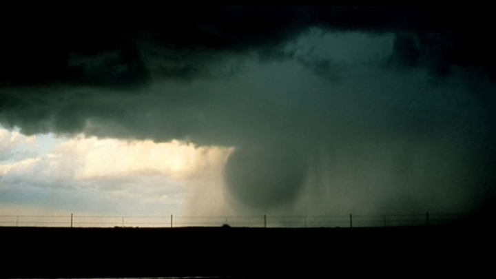
It's monsoon season in the American Southwest. Daily thunderstorms popping up over a dry landscape provide countless opportunities for passersby to take pictures and videos of the torrents as they bring an annual dose of rain to the otherwise parched desert. One of the more striking features of these desert thunderstorms is a term you see all over social media: microbursts. These destructive wind events can be terrifying to live through, but beautiful to watch from afar.
A microburst is a downward burst of damaging winds, rain, and hail that literally drops out of the bottom of a thunderstorm. A microburst occurs over a relatively tiny area; the extent of the strong winds is usually only a mile or two wide. From a distance, a microburst can look like a water balloon falling toward the ground, splashing outward upon impact like a mushroom cloud unfolding in reverse. Pictured above is a microburst with a classic water balloon appearance, spotted by NOAA scientists around 1980.
Meteorologists didn't give much thought to this phenomenon until the 1970s, when Dr. Ted Fujita—famous for his pioneering research into tornado intensity that led to the creation of the Fujita Scale—started to study the distinct pattern of damage that these windstorms leave behind.
You don't want to find yourself beneath a microburst. Just as with other destructive thunderstorms, some folks who experience these damaging winds insist that they really lived through a tornado. These winds come on suddenly, often going from a gentle breeze to a nightmarish windstorm within seconds, and can blow away anything not nailed down to the ground. Winds in a microburst can easily exceed 60 mph—but the strongest microbursts mimic the intensity of weak tornadoes, with winds peaking above 100 mph in some spots.

Different parts of the United States are prone to different types of microbursts. A wet microburst occurs with heavy rain or hail; these are common in humid areas like the southeast. A dry microburst, on the other hand, isn't accompanied by any precipitation at all; blowing dust and debris at the surface is often the only indication one of these events is occurring. Dry microbursts are common in places where there's not much humidity, like higher elevations or the desert.
Microbursts form due to two factors: evaporation and the weight of rain and hail. Evaporation is a cooling process; when liquid water turns to water vapor, it absorbs heat and cools the air around it. If dry air starts to invade the environment in or around a thunderstorm, it can cause rain to evaporate and leave behind large sections of air that are suddenly cooler than their surroundings. This less dense air sinks toward the ground, falling faster and faster until impact. The weight of the rain and hail also contributes to the speed of a microburst. Water is heavy, and that weight plays a big role in dragging cool air down from a thunderstorm. The two processes combined help create microbursts.
The biggest danger posed by microbursts is their sudden, sneaky formation. Microbursts happened with almost no notice at all until just the last decade or two. You didn't know it was happening until it happened. This surprise downward burst of winds and resulting wind shear can be potentially lethal to aircraft that are taking off and landing during thunderstorms. Microbursts have contributed to numerous airplane crashes over the years, killing hundreds of people.
We've gotten much better at detecting microbursts. The prevalence of Doppler weather radar across the United States, including smaller radars installed near most major airports, allows meteorologists to give people on the ground and in airplanes a little bit of advance notice before a microburst occurs. Wind shear detection systems both on the ground and installed in aircraft have also helped tremendously when pilots are flying into nasty weather.
Have you got a Big Question you'd like us to answer? If so, let us know by emailing us at bigquestions@mentalfloss.com.
