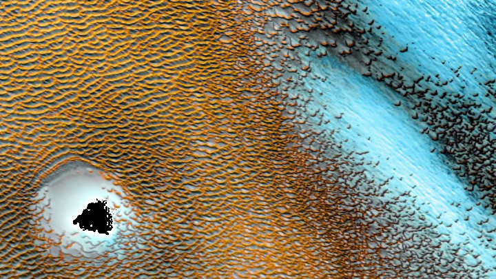
For the last 20 years, the orbiter Mars Odyssey has patrolled the Red Planet, transmitting data back to NASA so scientists can expand their understanding of Mars’s secrets. To celebrate the anniversary of its launch date on April 7, 2001, NASA released a breathtaking image of sand dunes that helps demonstrate what Odyssey has been up to and why it’s important.
The image above is a composite of photos captured by Odyssey’s Thermal Emission Imaging System, or THEMIS, between December 2002 and November 2004. The camera doesn’t just take snapshots—it also registers the temperature of the landscape. This way, scientists can distinguish between different materials on the surface of Mars (like sand, rock, or salt) based on temperature. When they map out itineraries for future visitors, rovers and humans alike, they'll know which areas are dangerous or resource-rich. “It’s hard to overstate how the THEMIS global map has filled gaps in our knowledge,” Laura Kerber, an Odyssey deputy project scientist working at NASA’s Jet Propulsion Laboratory, explained in a NASA feature.

In real life, the windswept sand dunes around Mars’s northern polar cap are dark. In the image, however, they’re depicted with colors that correspond to temperatures. The tops of the dunes, heated by the sun, look orange; the bluish or blue-gray spots are much colder. And while the picture only shows a 19-mile-wide section of the planet, the whole dune-covered terrain in that region stretches across an area of land roughly the size of Texas.
Mars Odyssey is currently the longest-operating spacecraft Mars has ever seen—and it’s not hanging up its hat (or thermal imaging camera) yet. You can learn more about the mission and its contributions here.
