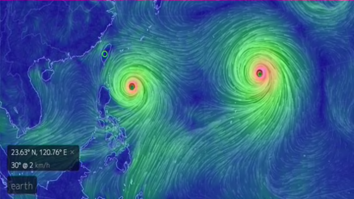
Goni and Astani sure do make a beautiful couple, though not one we’d wish to cross paths with anytime soon. Satellites and astronauts are keeping a close eye on the pair of typhoons as they brew over the Western Pacific.
Though they're still far from land, Typhoon Goni is projected to come very close to Taiwan and the Philippines by the end of the week. Astani, which has already been classified as a Super Typhoon, is fortunately not expected to have any major impact on land, though it’s currently headed in the direction of Northern Japan. If Goni reaches Super Typhoon status as well, it will be the first time since 1997 that two have formed in the Pacific simultaneously. Even as they are, the twin Typhoons make for a humbling sight. Here are some of the most breathtaking images of the storms captured from above.
Typhoon GONI is also getting bigger and stronger.. Too many typhoons these days..
— 油井 亀美也 Kimiya.Yui (@Astro_Kimiya) August 19, 2015
台風15号も勢力を増しています。警戒をお願いします。 pic.twitter.com/ZnKoh1WyNP
Typhoon Goni moving towards south-east Asia. The storm is likely to clip the east coast of Taiwan. pic.twitter.com/FpR25liR8Q
— Met Office (@metoffice) August 19, 2015
Typhoon Goni to enter PAR Tuesday, draw in monsoon rains anew http://t.co/g61zxAwHLk pic.twitter.com/q7CkwWfvqY
— Interaksyon (@interaksyon) August 16, 2015
As of late this morning we now have twin typhoons in the western Pacific, Goni and Atsani: http://t.co/U2Fz0xteei pic.twitter.com/j9ZZ5mgdCq
— The Weather Channel (@weatherchannel) August 16, 2015
Big #Typhoon #SOUDELOR Weakening Before Hitting China, #Goni and #Afsani Waiting http://t.co/qfoJSMNdVT pic.twitter.com/BsPdYc1D5M
— XWF WEATHER (@WeatherXwf) August 10, 2015
