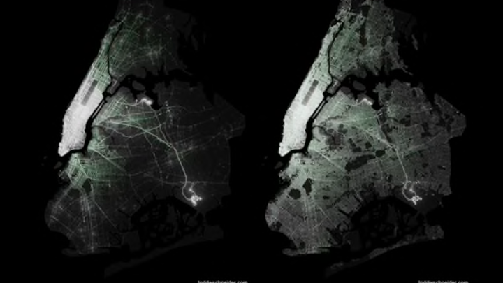
As a city with a relatively robust taxi ecosystem, New York makes a great place for data visualizations about how people move around. Every trip gets logged by the New York City Taxi & Limousine Commission. The commission recently released a giant pile of data on 1.1 billion taxi trips between 2009 and 2015, and software developer and data-viz enthusiast Todd Schneider took a deep dive into the numbers to pull out insights on where and how people travel in New York City.
He included the above visualizations on where taxis pick up and drop off in the city, including both yellow and green taxis (the latter can only pick up riders in the outer boroughs and upper Manhattan, and are shown in bright green on the map). The pick-up hotspots are pretty much where you might expect them to be: midtown Manhattan glows like a star, and JFK and LaGuardia airports are shining beacons in Queens.
However, the drop-off data shows that taxi use is relatively spread throughout the boroughs. Parts of the outer boroughs are basically pick-up free, including southern Brooklyn and East New York, but almost every street shows at least some drop-offs, even some in the far-flung Rockaways.
I wish there was a way to see the data broken up by year so that you could better see the impacts of the green taxi program and gentrification in newly hip neighborhoods like Bushwick on taxi use, but alas, that will have to be a job for another designer.
Check out Schneider’s full analysis here. It’s worth the read.
[h/t Kottke.org]
The Afternoon Map is a semi-regular feature in which we post maps and infographics. In the afternoon. Semi-regularly.
