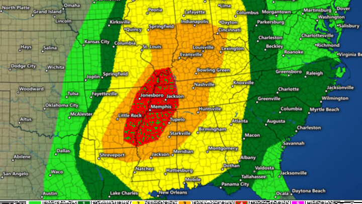
If your holiday travel plans take you through the southern United States this week, it would be a good idea to keep an eye on the sky and an ear glued to the local news outlets as you get ready for the long weekend. The latest forecasts point to the potential for a significant severe weather outbreak today from the Gulf Coast to the Midwest and from Texas to the Carolinas.
Much of the eastern United States is basking in the glow of a freakish warm spell right now, likely aided at least in part by El Niño. The warmth is so unusual that typically-snowy Buffalo, New York, only saw its first measurable snow on December 18, breaking a snow-free record that had stood since the presidency of Ulysses S. Grant.
The warmth will only get more intense this week as a strong low pressure system develops over the northern Plains, allowing southerly winds to drag unseasonably warm and moist air straight from the Caribbean, sending temperatures soaring dozens of degrees above where they’re supposed to be at the end of December.

Surface temperature anomalies on Wednesday afternoon, in °C, via Tropical Tidbits.
The Weather Channel predicts a high temperature of 74°F in Mobile, Alabama today, coming in 13° above normal for December 23. Charlotte, North Carolina is expected to see a high of 76°F on Thursday (Christmas Eve), which is a full 25°F higher than average for the date. Even New York City could see a high of 62°F and 72°F on Wednesday and Thursday, respectively, temperatures that are well above the city’s normal high of 41°F. And so the story goes for so many cities in the eastern United States and Canada, where long-standing records will shatter one by one as we sing Bing Crosby songs with the windows rolled down.
When it’s this warm this close to Christmas, not only is it a pleasant surprise, but it means you should be a touch nervous about what could happen next. The atmosphere will break this particular “heat” wave with an outbreak of scattered thunderstorms this week, culminating in a potentially dangerous severe weather day today.

Map: Dennis Mersereau // Forecast: SPC
The combination of warmth, moisture, wind shear (wind changing speed and direction with height), and air being forced upward by fronts and disturbances will allow for scattered severe thunderstorms to break out along and east of the Mississippi River today. As of Wednesday morning (December 23, 2015), the Storm Prediction Center—the severe weather forecasting division of the U.S. National Weather Service—is predicting a moderate risk for severe thunderstorms. On a scale from one to five, with a five being the most dangerous severe weather day possible, a “moderate risk” is considered a four. It’s relatively rare to see a moderate risk during the spring and summer, so it’s an unusual situation to see one on December 23.
The storms could produce several tornadoes—some of which could be strong and long-lived—damaging winds, and large hail. The greatest threat for violent tornadoes lies in and around the moderate risk area, but they’re possible for just about anyone expecting bad storms today.
A severe thunderstorm in the United States is defined as one that produces damaging wind gusts in excess of 58 mph, hail the size of a quarter (one inch in diameter) or larger, or a tornado. While we so commonly focus on tornadoes, all forms of severe weather are a threat to your safety, and you should take any threat seriously.

Map: Dennis Mersereau
That being said, the threat for tornadoes today is especially concerning since many people don’t look out for (or expect) dangerous thunderstorms when we’re waiting for Santa. We usually think of tornadoes as being synonymous with the spring and summer months, but they can occur at any time of the year, and they’re especially common in the Deep South in the winter. The above map shows all recorded tornadoes during the month of December between 1950 and 2014—there’s a clear pattern that emerges, and it’s that exact area that’s under the threat this week.
Severe thunderstorm events like this evolve quickly, so it’s imperative that you closely track weather forecasts, watches, and warnings if you live in an area expecting bad storms over the next couple of days. Local news stations are an excellent resource in a situation like this, as is your local National Weather Service office.
Remember that a severe thunderstorm or tornado watch means that a severe thunderstorm or tornado is possible over the next couple of hours, and you should stay alert. A severe thunderstorm or tornado warning means that dangerous weather is imminent, and you need to take immediate action to protect your safety. Mixing the two terms up could be a life-threatening mistake. The Storm Prediction Center issues watches for many counties at once, while your local National Weather Service office issues warnings for individual thunderstorms.
If your location is threatened by severe weather, the best course of action is to take shelter in a sturdy building and stay away from the windows until the storm has passed. If strong winds or a tornado is possible, get to the lowest level of your home and into an interior room, putting as many walls between you and the outdoors as possible. The goal is to prevent debris from striking you if the worst happens. If you’re out driving and a bad thunderstorm pops up, try to pull off the road to a parking lot if possible. Never take shelter under a bridge or overpass, as doing so can put you in even more danger, and endanger the people behind you in the inevitable traffic jam that ensues.
