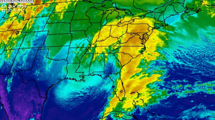
What is sure to be remembered as the Blizzard of 2016 is in full swing across the East Coast this afternoon as the storm winds its way through the Carolinas and heads for the Atlantic Ocean, where it will rev up into a powerful nor’easter. Blizzard warnings are in effect from the Washington D.C. metro area through New York City and Long Island, and winter storm warnings stretch west all the way to the Mississippi River. Heavy snow is on its way, and the storm will likely land in the record books by the end of this weekend.

Total forecast snowfall, in inches, from the National Weather Service as of 10:00 AM EST January 22, 2016. Image credit: NWS EDD
This is a complex storm with lots of moving parts, but the headline hazard is the extremely heavy snow getting ready to bury communities from Virginia to New York. A foot or more of snow is likely from Virginia to New Jersey, with 2 to 3 feet possible in western/northern Virginia and throughout the Washington D.C. area. New York City and its suburbs will be on the northern edge of the storm, where snowfall totals are a little more uncertain, but forecasters seem confident in predicting 12 to 18 inches of snow in and around the country’s most populous city.
Snow has begun to fall in Washington D.C., and it should descend in the evening hours in Pennsylvania and New Jersey, and reach New York City overnight on Friday. The snow will end on Saturday night and Sunday morning from south to north.
Not only are we dealing with heavy snow, but the wind will play a major role in this storm as we head into Friday night and Saturday morning. A blizzard warning is in effect for the cities lining Interstate 95 from northern Virginia through New York City in anticipation of strong winds and blowing snow leading to whiteout conditions. A blizzard is defined as 35+ mph winds creating blowing snow that limits visibility to one-quarter of a mile for at least three hours, creating a life-threatening, highly disorienting whiteout.
The strong winds will also coincide with a full moon, so high tides are expected to run 2 to 4 feet above average. Coastal flooding is a real concern for coastal communities in the Mid-Atlantic and Northeast, so if you live along the coast, prepare for flooding on top of wintry precipitation and very strong winds.

Total forecast ice accretion, in inches, from the National Weather Service as of 11:00 AM EST January 22, 2016. Image credit: NWS EDD
Snow isn’t the only concern with this storm. Warmer air along the southern edge of the low-pressure system is leading to an icy mess across the Carolinas today. The snow is mixing with freezing rain and sleet (ice pellets) in northern North Carolina, which is compacting the snow into a dangerous concoction of partially frozen slush, and freezing rain is entombing parts of North and South Carolina with a thick crust of solid ice. Some communities along Interstate 85 from Greenville, South Carolina, through Raleigh, North Carolina—including Charlotte—could see a half-inch to an inch of ice from freezing rain, which has the potential to cause extreme damage. Significant tree damage and power outages are likely in towns that see major ice accretion.
The weather models have done an excellent job with this storm, locking in on the greatest hazards nearly a week ago, giving forecasters confidence to warn the public well ahead of time. This is one storm where nobody can honestly claim they were taken off guard. The models have gone so far as to predict extreme amounts of snow in the Washington D.C. area, in particular—so much so that the city could rival its all-time snowfall record if the storm lives up to what the models show could happen.
The most snow ever recorded in one storm in Washington D.C. was 28 inches back in January 1922 during the Knickerbocker blizzard. The city’s official recording station is now located at Reagan National Airport just across the Potomac River in Arlington, Virginia, and if that station records more than 20 inches of snow, it will claim the second spot on the city’s list of biggest snowstorms. Washington D.C.’s suburbs often get much more snow, and the biggest storm ever recorded at Dulles International Airport—located in suburban Virginia about 25 miles west of the city—was 32 inches back in February 2010. It’s unlikely that Dulles Airport will see its heaviest snow ever recorded, but it’s possible that this could be its second largest on record.
