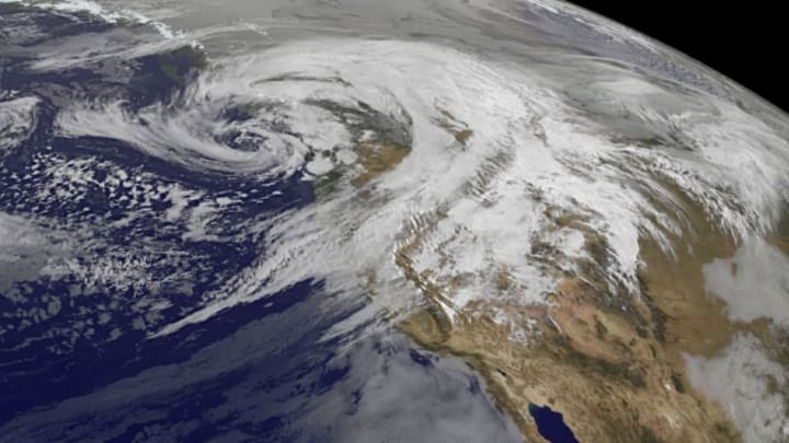
Most of the exciting weather that blows across the United States unfolds east of the Rocky Mountains. The West Coast has a reputation for relatively boring, stable weather compared to the endless torrents out east, but every once in a while they’ll get a storm that tears into the coast as hard as a hurricane. This week, the Pacific Northwest will deal with two such storms slamming into the coast, one after the other. The first storm caused some bad weather on Thursday night and this morning, while the second storm is expected to strike tomorrow, Saturday, October 15, with even more ferocity than the one before it.
The story of these two storms is that they’re roughly equivalent to category 1 hurricanes hitting the Pacific Northwest in rapid succession. We spend days and sometimes weeks focusing on much lesser storms spinning around in the Atlantic Ocean, yet large, damaging low-pressure centers swirling on the other side of the country get only a fraction of the attention. Each storm will have similar effects to a hurricane—damaging winds, heavy rain, coastal flooding, and rough seas—and even though neither storm is a hurricane by definition, they should be treated just as seriously.
The first storm approached the Northwest coast on Thursday night and Friday morning, focusing the brunt of its foul weather on Oregon and Washington to end the workweek. The National Weather Service office in Portland, Oregon, collected widespread reports of 55 to 65 mph wind gusts across western Oregon, which is enough to do some damage to trees and power lines. Some of the gusts were even higher—an elevated weather station near the coast in Oceanside, Oregon, measured a wind gust of 103 mph on Thursday night. A few of the thunderstorms in Oregon even spawned tornadoes, one of which hit a small town about 60 miles west of Portland on Friday morning.
If that wasn’t bad enough, another storm is on its way this weekend that looks like it will be even stronger than the first one. This Saturday’s storm, though not an actual hurricane, does have its roots in the tropics. The impending system will gather some of its strength by incorporating the remnants of Super Typhoon Songda, a tropical cyclone that had 150 mph winds out in the western Pacific Ocean earlier this week. As the storm traveled into the higher latitudes, it lost its tropical characteristics and hitched a ride in the jet stream, speeding east across the entire ocean in just a couple of days. The storm will also have ample moisture to work with due to an atmospheric river, or a stream of deep moisture that flows north from the tropics.
As we saw with the storm on Thursday and Friday, strong winds will be the greatest threat this weekend. High wind watches are in effect for coastal and inland areas of northwestern California all the way to the Canadian border in Washington in anticipation of winds that approach hurricane force during the day on Saturday. This includes the cities and suburbs of Portland, Oregon, and Seattle, Washington. Widespread wind gusts of 60 to 70 mph will knock down trees, sever power lines, and possibly cause damage to buildings. The wind might have an easier time tearing down trees because the soil is wet and many trees still have their leaves, which creates a sort of parachute effect, catching the wind and putting even greater stress on the trees.
Several inches of rain are possible ahead of the system, with higher totals falling in higher elevations. Forecasters don’t expect widespread flooding to be an issue, but some minor flooding is possible as a result of freshly downed leaves clogging up sewage systems and small creeks.
The culprit behind the two hurricane-strength storms is an intense jet stream dipping over the northwestern United States. Winds in the jet stream are screaming along at nearly 200 mph, which creates intense lifting motion through the atmosphere around the jet stream. Air rapidly rises from the lower levels of the atmosphere as a result of this lift, creating a center of low pressure at the surface. The strength of this particular jet stream will allow the low-pressure systems to grow unusually strong, which is why both systems have and will produce such strong winds.
The Pacific Northwest has an ugly history with damaging windstorms. Storms with this intensity occur every couple of years, and the storm forecast to blow ashore this weekend could produce wind gusts on par with some memorable storms in recent years, including storms in December 2006 and December 1995.
