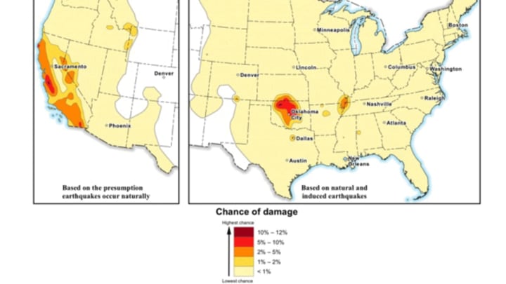
Americans living near major fault lines aren't the only ones vulnerable to earthquakes. Newly released maps from the U.S. Geological Survey (USGS) shows that areas with heavy gas and oil drilling activity are also at risk, NPR reports.
Maps previously published by USGS have only shown naturally occurring earthquakes, but in recent years the cases of human-induced quakes have become too frequent to ignore. That frequency—a result of oil and gas operations—has meant that earthquakes are now present in states where they don't naturally occur.
Processes like hydraulic fracturing (fracking) produce a byproduct of polluted water, and drilling companies dispose of it by injecting the wastewater into underground waste wells. The added pressure beneath the surface sometimes causes faults to shift, resulting in small quakes that wouldn't have occurred otherwise.
Of fracking, the USGS writes: "Many questions have been raised about hydraulic fracturing … USGS studies suggest that this process is only rarely the cause of felt earthquakes."
In states like Oklahoma, where oil output doubled between 2010 and 2013, earthquakes are at a record high. Oklahoma now averages nearly three quakes a day, compared to just the one or two a year prior to 2008. While most of them are too weak to do any serious damage, stronger examples, like the 4.5 magnitude quake that hit Crescent, Oklahoma last year, have been known to occur. Texas, Colorado, Arkansas, Kansas, and New Mexico are also states where human-caused earthquakes have been on the rise in recent years.
USGS's new maps include statistics for earthquakes that occur naturally in the country as well, which have remained fairly consistent.
[h/t NPR]
